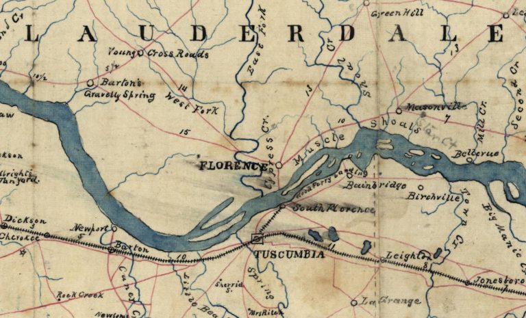

Thousands of people in Florence cross Cypress Creek every day. Its name appears on road signs, maps, businesses and neighborhoods throughout the city. If you’re from Florence, you’ve heard of it, but more than two centuries ago, the creek was recorded under a very different name.
Te Kee, ta, no-eh.
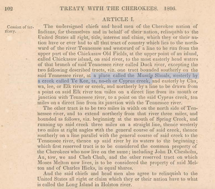
This Cherokee name for the creek appears in an actual treaty between the Cherokee Nation and the United States signed in Washington on January 7, 1806.
In describing land at Muscle Shoals, the treaty identified its western boundary as: “a creek called Te Kee, ta, no-eh or Cyprus creek.” “Cyprus” was an early spelling used for what we now spell as Cypress Creek.
That single line in a 200+ year old document preserves something that is forgotten today. Long before Florence existed, the streams, rivers and valleys of the Shoals were already known, inhabited and named.
Cypress Creek: A Cherokee Boundary at Muscle Shoals
The January 1806 agreement was one of a series of treaties through which the United States acquired enormous amounts of Native American land during the late 18th and early 19th centuries.
On paper, these documents describe orderly transactions between governments. They use words such as cede, relinquish and agreement. The reality was considerably more complicated.
The United States was expanding rapidly, and obtaining Native American land was an established government objective. Cherokee leaders faced mounting pressure to surrender territory as white settlement pushed farther west.
The Cherokee themselves were deeply divided over these land cessions. The treaties of 1805 and 1806 became particularly controversial within the Cherokee Nation, where opponents accused a relatively small group of chiefs of abusing their authority and personally benefiting from the agreements. Chief Doublehead was at the center of that controversy.
The anger eventually became so intense that Doublehead was killed by fellow Cherokees in 1807. So while the documents preserved in Washington describe land being legally “ceded,” there is another way to understand what happened, and one I believe deserves to be stated plainly.
The Cherokee were coercively being dispossessed of their land. The National Park Service itself says land cessions were increasingly “forced on the Cherokee.”
The process had the appearance of legality because it was carried out through treaties. But those treaties existed within an enormous imbalance of power between an expanding United States and Native nations increasingly surrounded by American settlement.
In even plainer language, the land was being taken.
The Land Between Two Cherokee-Named Creeks
Interestingly, the 1806 treaty did not immediately surrender all of the Cherokee land around Muscle Shoals. One tract was specifically reserved. Its southern boundary was the Tennessee River. Te Kee, ta, no-eh (Cypress Creek) formed its western boundary, while another Cherokee-named stream, Chu, wa, lee (the Elk River) formed the eastern boundary.
From those streams, the reservation extended approximately ten miles north of the Tennessee River. The treaty called this tract the common property of the Cherokees living there. Chief Doublehead was one of the Cherokee leaders who signed the agreement, and the reservation subsequently became closely associated with him as Doublehead’s Reserve.
The Reservation Disappears
Only eleven years later, another treaty was signed. On July 8, 1817, representatives of the United States and Cherokee Nation met at the Cherokee Agency. Among the American commissioners was Andrew Jackson.
Article 10 of the treaty declared that the Cherokee Nation ceded to the United States its claims to the reservations made to “Doublehead and others” under the January 7, 1806 agreement.
With those words, the reservation bounded by Te Kee, ta, no-eh passed into the hands of the United States. Again, the official document uses the language of a negotiated cession, but by this period, the pattern is difficult to ignore.
Treaty after treaty reduced the Cherokee land base as the United States expanded. The pressure continued until Cherokee leaders declared in 1819 that they would make no further land cessions. Even that would not ultimately protect what remained of their homeland.
Within another generation, the federal government would pursue removal of the Cherokee from the Southeast altogether, culminating in the forced migration remembered as the Trail of Tears.
A Name That Survived: Cypress Creek
The transformation of the Shoals happened quickly after the United States obtained control of the land. Florence was founded in 1818. Surveyors arrived. Land was divided and sold. Roads were constructed. Farms, businesses and communities appeared, and the names on the landscape changed. Te Kee, ta, no-eh became Cypress Creek.
Today, there is little about the name Cypress Creek that hints at the world that existed here before American settlement. That’s one reason the old name matters. Place names are small pieces of history. Sometimes they survive for centuries. Sometimes they are replaced so completely that almost no one remembers there was ever another name.
Fortunately, in this case, someone wrote it down more than 200 years ago, when the United States government needed to describe precisely where Cherokee land at Muscle Shoals began and ended. The treaty recorded the creek by the name associated with it at that time: Te Kee, ta, no-eh.
Sources & Further Reading
- Treaty with the Cherokee, January 7, 1806. Indian Affairs: Laws and Treaties, 7 Stat. 101. Oklahoma State University Digital Treaties.
- Treaty with the Cherokee, July 8, 1817. Indian Affairs: Laws and Treaties, 7 Stat. 156. Oklahoma State University Digital Treaties.
- National Archives — Indigenous Digital Archive, Treaties Explorer. Digitized original of the January 7, 1806 treaty between the United States and the Cherokee Nation. National Archives Identifier 105244379.
- National Park Service. “Cherokee Relations with the U.S. Government Before Removal.” Fort Smith National Historic Site.
- National Park Service. “The Trail of Tears and the Forced Relocation of the Cherokee Nation.”
- Sockwell, Sandra. The Place Names of Colbert and Lauderdale Counties, Alabama. 2 vols. Ph.D. dissertation, University of Alabama, 1985. Copies are held in the local-history collection of the Florence-Lauderdale Public Library.