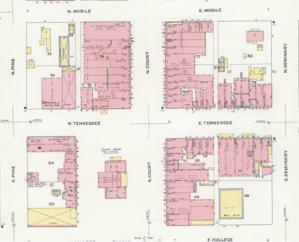

Sanborn Fire Insurance maps are some of the most useful records available for researching old houses, businesses, neighborhoods, and entire towns. They can show what buildings once stood on a property, what they were made of, how many stories they had, and sometimes even how they were used.
At first glance, though, a Sanborn map can look like a confusing collection of colors, numbers, letters, and strange symbols. Fortunately, once you understand the Sanborn map key, they’re surprisingly easy to read.
Sanborn Fire Insurance maps use colors, numbers, abbreviations, and symbols to describe buildings. Yellow typically represents frame construction, red or pink represents brick, and blue represents stone. Numbers inside buildings usually indicate the number of stories. Symbols can identify roof materials, windows, doors, fire walls, boilers, and other features.
Here’s how to decipher them.
What Are Sanborn Fire Insurance Maps?
Sanborn maps were originally created for the fire insurance industry. Insurance companies needed detailed information about buildings and neighborhoods to determine the risk of fire.
That meant Sanborn surveyors recorded an extraordinary amount of information, including:
- building construction
- number of stories
- roof materials
- windows and doors
- fire walls
- building use
- property boundaries
- street addresses
- water mains and fire hydrants
- boilers and other industrial equipment
For historians, genealogists, preservationists, and property researchers, that insurance information provides something remarkably close to a snapshot of a community at a particular moment in time.
Start With the Sanborn Map Key or Legend
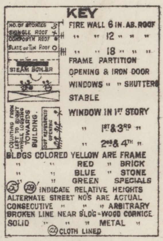
Before trying to interpret an individual map, find the key or legend for that particular Sanborn edition. The key explains the colors, lines, numbers, abbreviations, and symbols used throughout the maps.
Sanborn’s system was fairly standardized, but it changed over time. That means you shouldn’t assume a symbol found on an 1880s map necessarily means exactly the same thing on one produced several decades later.
The keys themselves are fascinating documents. They can explain symbols for everything from shingle roofs and windows to steam boilers, fire walls, stables, and iron shutters. Once you understand the key, the map begins to look much less mysterious.
What Do the Colors on Sanborn Maps Mean?
Color is one of the quickest ways to learn something about a building. On Sanborn Fire Insurance maps, the color of a building generally indicates its construction material.
A typical Sanborn key may include:
| Color | Typical Meaning |
|---|---|
| Yellow | Frame or wood construction |
| Red/Pink | Brick construction |
| Blue | Stone construction |
| Gray | Iron construction |
| Brown | Adobe |
| Green | Special construction |
The exact meanings can vary somewhat depending on the map and period, which is why the original key should always be consulted. For most research in the Shoals, the two colors you’ll probably encounter most often are yellow and pink.
A yellow building was generally constructed of wood.
A pink or red building was generally constructed of brick.
That distinction alone can reveal quite a bit about the history of a property.
Suppose an entire commercial block appears yellow on an early Sanborn map but is pink on a later edition. Something significant probably happened between those two surveys. The wooden buildings may have burned, been demolished, or simply been replaced as the business district developed.
That’s when the Sanborn map becomes the beginning of the research rather than the end.
What Do the Numbers on Sanborn Maps Mean?
Numbers written inside building footprints often indicate the number of stories.
For example:
1 — one story
2 — two stories
3 — three stories
You may also encounter combinations of numbers and letters indicating additional characteristics such as basements. Different portions of the same building can even have different numbers.
A commercial building might have a 2 in its front section and a 1 in a rear addition. That tells you the main building was two stories tall while the addition was only one. This can be particularly useful when comparing Sanborn maps with historic photographs.
Sanborn Map Roof Symbols
Roof construction mattered enormously to fire insurers.
A wooden shingle roof represented a very different fire risk than a slate or metal roof, so Sanborn maps used symbols to identify different roof materials.
Depending on the edition, the key may distinguish between:
- shingle roofs
- composition roofs
- slate roofs
- tin or metal roofs
Instead of writing the roof material on every building, surveyors could simply place the appropriate symbol on the structure. These tiny markings are easy to overlook, but they can reveal details about a historic building that may not survive in any photograph.
Windows, Doors and Shutters on Sanborn Maps
Small markings along the exterior walls of buildings can indicate windows, doors, and other openings.
Sanborn keys may distinguish between:
- first-story windows
- upper-story windows
- ordinary doors
- iron doors
- iron shutters
- openings between buildings
Insurance companies cared about these details because openings affected how easily fire could spread. For historians, the same information can sometimes help reconstruct the appearance of a building that has been significantly altered (or has disappeared entirely).
How to Identify Fire Walls
Fire walls were another important feature recorded by Sanborn surveyors. The keys shown on many maps distinguish between masonry walls extending different distances above the roof, sometimes including:
- 6 inches above the roof
- 12 inches above the roof
- 18 inches above the roof
These walls could help prevent fire from spreading from one building to the next. They may also explain something you can still see on historic downtown buildings today: masonry partition walls extending above the roofline between adjoining storefronts.
What Do Solid and Broken Lines Mean?
Even the type of line used on a Sanborn map can contain information. Depending on the map’s key, solid and broken lines can identify features such as:
- exterior walls
- frame partitions
- fire walls
- openings
- roof construction
- cornices
Again, check the key belonging to the particular Sanborn map you’re using. The maps span such a long period that relying on a generic list of symbols can occasionally lead you astray.
Common Sanborn Map Symbols and Abbreviations
Sanborn maps frequently use abbreviations to identify how a building was being used.
Some common examples you may encounter include:
D or Dwg. — Dwelling
D.G. — Dry Goods
S — Store
Sal. — Saloon
Whse. — Warehouse
Stable — Stable or livery-related building
You’ll find many others.
Hotels, churches, schools, factories, cotton warehouses, blacksmith shops, drug stores, groceries, offices, and other businesses may be labeled directly.
Industrial buildings can be especially detailed. Because they presented greater fire risks, Sanborn surveyors sometimes recorded boilers, machinery, elevators, fuel storage, and other equipment.
For local history research, these labels can be invaluable. A building remembered simply as an “old store,” for example, might turn out to have been a grocery in one edition, a saloon in another, and a warehouse twenty years later.
How to Read a Sanborn Map’s Building Footprints
Don’t concentrate so heavily on the symbols that you overlook the shape of the buildings themselves. Sanborn maps were drawn at a large enough scale to show individual structures and many of their architectural features.
You may be able to identify:
- front porches
- rear additions
- detached kitchens
- sheds
- stables
- warehouses
- storefronts
- narrow passages between buildings
This becomes particularly useful when comparing multiple editions.
A small house on one map might have a new rear wing on the next. A vacant lot might suddenly contain a store. Two small buildings may disappear and be replaced by one large brick building.
For someone researching an old house, Sanborn maps can sometimes help narrow down when an addition was constructed.
How to Use a Sanborn Key Map
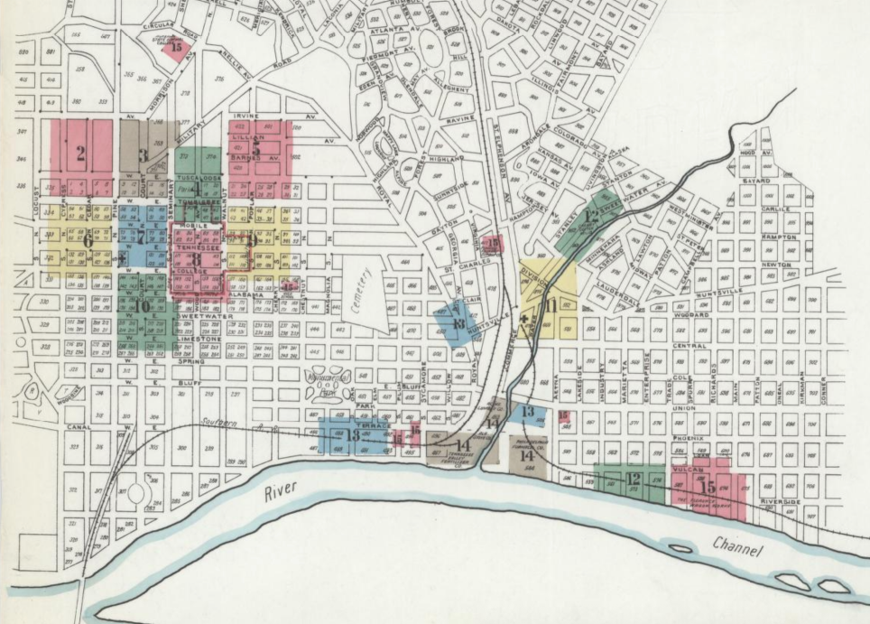
A Sanborn atlas covering a large town or city could contain dozens—or even hundreds—of detailed map sheets. That’s where the Key Map or graphic index comes in.
The citywide key map is not intended to show every individual building. Instead, numbered areas tell you which detailed sheet contains a particular neighborhood or block.
If the property you’re researching falls within an area marked 13, for example, you would turn to Sheet 13 for the detailed view.
Think of the key map as the table of contents for the Sanborn atlas. This is usually the fastest way to locate a particular street or neighborhood.
Be Careful With Old Street Numbers
Street numbers appear throughout Sanborn maps, but don’t automatically assume an old number corresponds to today’s address. Cities sometimes changed their street-numbering systems.
Sanborn surveyors also occasionally assigned numbers for mapping purposes when reliable street numbers weren’t available. Some Sanborn keys specifically distinguish between actual and arbitrary street numbers.
When identifying a historic property, it’s better to use several pieces of evidence together:
street name + cross streets + position on the block + building footprint + neighboring properties
If all of those line up, you can be much more confident that you’ve found the correct building.
Sanborn Maps Can Reveal Buildings That No Longer Exist
This may be the greatest value of Sanborn Fire Insurance maps. Look at a modern parking lot and you see a parking lot. Find that same property on an 1890 Sanborn map and suddenly it may contain houses, stores, stables, warehouses, alleys, and outbuildings.
Better still, compare several editions:
1888: Wooden dwelling
1894: Dwelling with a new rear addition
1903: Brick commercial building
1910: Expanded storefront
1920: Warehouse
Today: Parking lot
You’ve just reconstructed decades of physical history from a handful of maps. Then you can turn to newspapers, deeds, city directories, photographs, and other sources to find out what happened.
Watch the Date of the Sanborn Map
There’s one important complication when dating something with a Sanborn map.
The date printed on the atlas doesn’t necessarily mean every feature shown on the map dates from that year.
Sanborn frequently updated existing map sets with corrections.
You may encounter an atlas identified with a range such as 1912–1950. In a case like that, 1912 may represent the original publication while later corrections reflect changes made over subsequent decades.
If you’re trying to establish exactly when a building appeared or disappeared, check the map’s publication information and revision history carefully.
How to Research a Property Using Sanborn Maps
When I’m researching an old building or business, this is the basic process I use:
- Find the property on the key map. Determine which detailed sheet covers the area.
- Locate the property using streets and neighboring buildings. Don’t rely entirely on the historical street number.
- Check the building color. This usually tells you its primary construction material.
- Look for the number of stories.
- Identify the building’s use. Look for labels and abbreviations.
- Study the footprint. Note porches, additions, outbuildings, and adjoining structures.
- Check the smaller symbols. Roofs, windows, doors, fire walls, and other details may provide additional clues.
- Find the same property on another Sanborn map.
- Compare what changed.
- Use other historical records to figure out why.
That last part is where Sanborn maps become especially useful.
Suppose an 1894 map shows four wooden stores on a block, while an 1899 map shows one large brick building occupying the same property. The map doesn’t necessarily tell you what happened.
But it gives you a five-year window to search old newspapers for a fire, demolition, construction announcement, property sale, or redevelopment. Suddenly, you’ve got a lead.
Why Sanborn Maps Are So Valuable for Local History
Sanborn maps were created to answer a fairly mundane question:
How risky would this property be to insure against fire?
More than a century later, we’re asking completely different questions.
What stood here before this building? When was that addition constructed? Was this originally a house or a business? Was downtown Florence mostly wooden buildings? Where was the town’s livery stable? How large was that hotel? What buildings surrounded the Lauderdale County Courthouse?
Fortunately for us, answering the insurance companies’ questions required Sanborn surveyors to record exactly the sort of details historians wish someone had written down.
Once you learn the colors, numbers, symbols, and abbreviations, a Sanborn Fire Insurance map stops looking like a maze of strange markings.